
Downloads
Full view (jpeg: 84.62 KB)
Learn more about copyright and access restrictions for use of materials from Worthington Memory.
Worthington Section of the 1936 Columbus Redlining Map is cartographic material, with genre map.
It was created on Wednesday, February 19, 1936.
Home Owners' Loan Corporation is the Creator. Worthington Libraries is the Contributor.
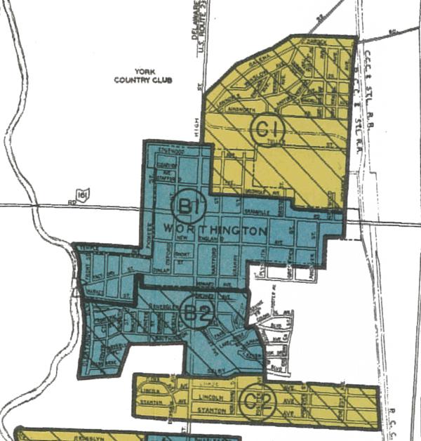
This is a cropped image of the 1936 redlining map for the City of Columbus, showing the area encompassing Worthington. The area is bounded by the Olentangy River on the west, the railroad tracks on the east, just beyond Worthington-Galena Road on the north, and just beyond Stanton Avenue on the south.
In the 1930s, the federal Home Owners' Loan Corporation began creating "residential security maps" of more than 200 cities, meant to indicate the level of security for real estate investments. The areas considered most desirable for lending purposes were designated Type A and outlined in green. "Still desirable" areas were Type B and outlined in blue. Type C areas were "definitely declining," and were outlined in yellow. And Type D neighborhoods, considered "hazardous" for mortgage support, were outlined in red.
The federal government deemed these "redlined" areas likely to see declines in property values, and thus not eligible for homeownership and lending programs. It’s no coincidence that redlined areas were neighborhoods where Black residents lived.
The areas shown on the Worthington section of the map are Type B, blue, in the areas of Old Worthington and Riverlea, and Type C, yellow, in the areas north and south of there.
While no areas were outlined in red, other tactics drove housing discrimination in Worthington. Beginning in the 1920s, new housing developments in Worthington, as well as across the country, were platted with restrictive covenants, limiting ownership and occupancy of the homes to white residents. In fact, the Federal Housing Administration required racial restrictions for new subdivisions to qualify for federal mortgage assistance. Neighborhoods such as Colonial Hills, Riverlea, Detrick Estates and Medick Estates were all platted with racially restrictive covenants.
It covers the topics homes, racism, real estate and neighborhoods.
It covers the city Worthington.
You can find the original at Worthington Libraries.
This file was reformatted digital in the format video/jpeg.
The Worthington Memory identification code is wpl0577.
This metadata record was human prepared by Worthington Libraries on August 11, 2023. It was last updated August 21, 2023.